One colour
and a wide spectrum of Earth monitoring solutions


and a wide spectrum of Earth monitoring solutions
Speech on "Challenges of remotely sensed image processing and analysis: optimizing the use of new available technologies with users needs." Will be presented on Wednesday November 12th @ 10:30 at the "Turquoise Geosolutions" Room.

Explore the potential of a variety of remotely sensed imagery from the free data offered by the new Landsat 8 or the new commercial technologies such as high resolution satellites, UAVs, radar and lidar. This hands-on workshop will cover straight forward image processing and analysis tools producing a variety of geospatial layers commonly required for resource, environmental and territorial management in the Albertan context.
Auracle Remote Sensing, the canadian partner of Skybox, is developping a new generation of image analysis tools for SkySat-1 and 2 video mode.
ENVI products create the premier geospatial software foundation to process and analyze all types of imagery and data such as multispectral, hyperspectral, LiDAR, and SAR.
The ENVI Platform fully integrates with ArcGIS® from Esri, allowing you to add more information than ever before to your GIS for more powerful geospatial products. With access to ENVI image analysis tools directly from the ArcGIS desktop and server environments you can increase efficiency and improve decision making.

IDL is the trusted scientific programming language used across disciplines to extract meaningful visualizations out of complex numerical data.
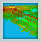
ENVI LiDAR is an interactive geospatial software environment that lets you create realistic 3D visualizations and easily extract important features and products from raw LiDAR point cloud data. The elevation information contained within LiDAR can be used to create Digital Elevation Models (DEMs), or be included in your geospatial products like line-of-sight or right-of way analyses. ENVI LiDAR can also be customized with the API to meet the unique needs of your organization.
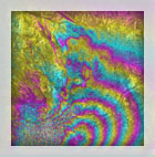
ENVI SARscape® allows you to easily read, process, and output your SAR data so you can transform hard-to-interpret data into meaningful, contextual information. Synthetic Aperture Radar (SAR) data is a sophisticated data type that can be used to analyze an area of interest during the day or night, regardless of weather conditions. It is particularly helpful when trying to detect change and study the topography of a specific area.